Scottish Geology: Observations both Amateur & Professional.
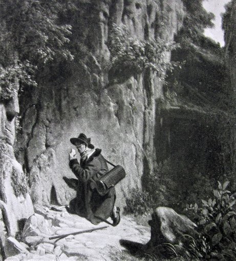
Der Geologe. After a painting by Carl Spitzweg.
"There are few parishes in Scotland that furnish such a rich field to the speculations of the geologist - both from its extent, and the variety of its formations." So wrote the Rev. William Findlater in the 1845 New Statistical Account of Scotland. I don't think he could have had any idea of exactly how right he was in saying this, for some 40 years later, it was found that Sutherland contains some of the most remarkable geology, not just in Britain, but in the whole world.
I am no geologist, so there is no danger of my dazzling you in this article with complicated science. However, I was always interested to see what the various visitors of the 18th and 19th centuries made of the rocks, and the landscape of the area, and I find in the notes made for my book, The Immeasurable Wilds a number of references which I thought I would share with you. I will not be confining myself to the far north, but rather to Scotland in general, and from these often amateur observations, an understanding of the science may emerge that adds to the appreciation of this remarkable and beautiful region.
The First Visitors.
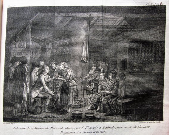
Geology was still a very young science in the 17th and 18th centuries. John MacCulloch, who in 1819 published one of the most important books on the geology of the North-West of Scotland, chides Martin Martin for his "tale of the two stones, which certain combating Giants threw at each other", further complaining that such folklore has been used "all the world over" to explain the occurence of Islands. Certainly Martin's book A Description of the Western Islands of Scotland mentions frequently the tales of the local inhabitants that the author comes across. So, on Fladda, he writes of "a Chappel on the Isle [with] an Altar in the East-end, and there is a blue stone of a round form on it, which is always moist. It is an ordinary Custom, when any of the Fishermen are detained in the Isle by contrary Winds, to wash the blue stone with Water all round, expecting thereby to obtain a favourable Wind...The stone is likewise applied to the sides of people troubled with stitches...." But he is also capable of serious observation, such as on his native Skye, where he observes Marcasites near Sartle, Agate at Applesglen, and Crystals in several places on the islend. He goes on to mention the Marble found at Torrin in Strath, and in the same place, the abundance of limestone.
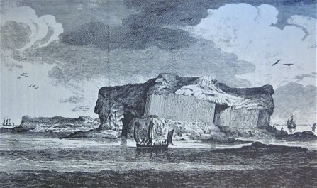
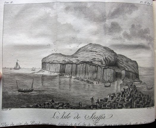
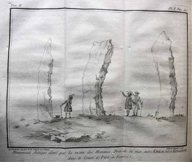
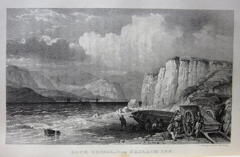
The majority of the early visitors to the far north wrote in fairly general terms about the landscape they found there. General Roy, who surveyed Scotland in the 1750s, thought Assynt "infinitely more rugged and broken than any other part of Britain. In order to convey any tolerable idea of a country so very extraordinary in its nature, we may suppose some hundreds of the highest mountains split into many thousands of pieces, and the fragments scattered about." Perceptive indeed, for some 130 years later, Lapworth "believed that the Highlands of Scotland include a portion of an old mountain system, formed of a complex of rock formations of very different geological ages, which have been crushed and crumpled together by excessive lateral pressure..." (John Horne, in the 1907 Geological Survey Memoir). Thomas Pennant formed a similar impression: he observed in Assynt "very great precipices of limestone, mixed with marble, from hence a most tremendous view of mountains of tremendous height, and generally conoid form. I never saw a country that seemed to have been so torn and convulsed: the shock, whenever it happened, shook off all that vegetates...." Tom Furniss, in his excellent and approachable (for the non-geologist) Discovering the Footsteps of Time suggests that Pennant's contribution to the early history of geology has been underestimated, pointing out that he in fact 'discovered' Staffa before Joseph Banks in 1772 (see image above, from Pennant's 1772 Tour in Scotland). Later visitors experienced the same emotions: Charles St John wrote in 1849 "the mountains at the head of Loch Eriboll are as wild as can be imagined; consisting of irregular piles of grey rock, thrown together in every kind of confusion...."
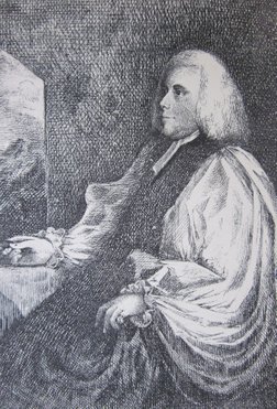
Bishop Pococke (left), visiting the far north in 1760, was an experienced traveller, "viewing everything that was curious, and carrying away with him a variety of fossils, stones, minerals, and other natural curiosities" (The Cambridge Chronicle, 1765). At Cape Wrath, he spotted "a beautiful head of marble with white streaks in it, and red spots, it seems to be black." Later, he observed "rocks on each side with a harder kind of marble between the strata, which remained proof against the weather, for about two inches of thickness, and is of a black colour, whilst the stone above was worn by the weather."
James Robertson, the botanist who researched the area in the 1760s, was another who could claim some pretensions as a serious geologist. He is scornful of the adder stone that Mrs Gordon shows him at Fotherletter, which was reputed to make people prosper ("By scratching it with a bit of flint, I found that it was made with glass"), whilst on Ben Awin, he noted that "the mountain is composed of white granite. Its grain is coarse, and the stone is hard, tho' it easily moulders down when exposed to the air: hence the higher and more prominent parts appear as if their surface has been covered with gravel. In this hill three fourths of the Granite consists of Crystals." Robertson
made similar careful notes like this throughout his tours.
Joseph Banks Reveals Staffa to the World.
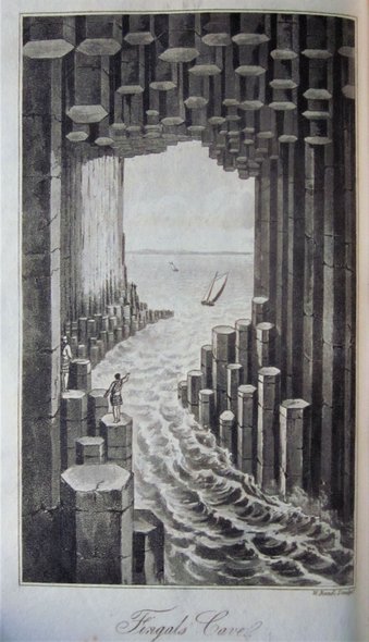
If Thomas Pennant was the first man to record Staffa, it was Joseph Banks' visit later in 1772 that proclaimed to the world the wonders of this small island. His account was published in Pennants Tour in Scotland and Voyage to the Hebrides 1772. Having heard rumours that the island "contained pillars like those of the Giant's Causeway", his party made their way to Staffa, arriving in darkness. Having pitched their tent, and had their supper, so impatient were they to explore that "...everyone was up and in motion before the break of day, and with the first light arrived at the south-west part of the island...where we no sooner arrived than were struck with a scene of magnificence which exceeded our expectations...." Banks was one of the first of many to compare the strutures he found there to the finest architecture of man: "Compared to this, what are the cathedrals or the places built by men? Mere models or playthings..." He then goes on to give a detailed account of all the structures of the island.
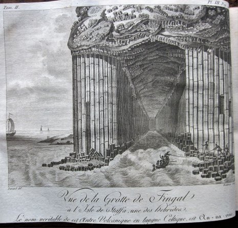
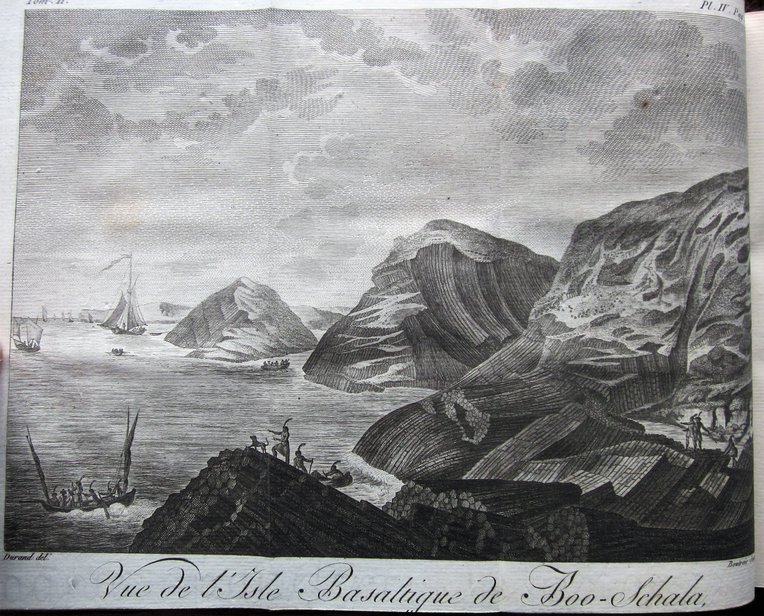
Banks' account drew the first professional geologist to the island in 1784, a frenchman called Barthelemy Faujas de Saint-Fond. A debate concerning the nature of basalt rock had been conducted in France for some time after a realisation had dawned that the centre of France contained a number of extinct volcanoes. Lured to Scotland by the rumours of volcanic evidence, he found much to interest him, not least at Edinburgh where he "formed a large collection of volcanic substances, and other interesting mineralogical specimens". But it was Staffa that excited him the most: "I have seen many ancient volcanos, and I have given descriptions of several basaltic causeways and delightful caverns in the midst of lavas. But I have never found anything which comes near this [Fingal's Cave], or can bear any comparison with it, either for the admirable regularity of the columns, the height of the arch, the situation, the forms, the elegance of this production of nature, or its resemblance to the master-pieces of art...It is therefore not at all surprising that tradition should have made it the abode of a hero."
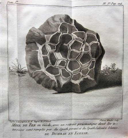
Engravings from Faujas' account of his travels, published in 1797:
Other geologists were drawn to Scotland from Europe. L.A. Necker de Saussure was sent to Edinburgh University from 1806 - 1808. He wrote two books on his experiences in Scotland, both of which were translated into English and published by Sir Richard Phillips in 1821/22. Like Faujas, he was astonished at Staffa, his experience within Fingal's Cave being enhanced by the presence of a piper, whose instrument "well accorded with the character of the scene, and the notes prolonged by the echoes produced an effect altogether analogous to that of an organ in pealing through the vaulted isles of a vast cathedral." The image of Fingal's Cave as a cathedral is one that is used frequently in descriptions of Staffa.
Images taken from Necker de Saussure's A Voyage to the Hebrides... (1822):
Necker was so delighted with Scotland that he returned in 1841, and took up residence in Portree in Skye, where he is buried. I hope to devote a page on this website to his writings in the future, as they are of some interest, not just on the subject of geology.
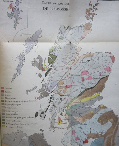
It was a Frenchman, Emanuel Boue, who published the first geological map of Scotland in 1821:
Hardly a detailed assessment of the geology of the country, especially in the far north where he admits to relying heavily on the work of John MacCulloch, but it is a start. Like Necker de Saussure, Boue spent time at Edinburgh as a student, where Robert Jameson was professor. As a sign of how little the science had developed at this time, Jameson, who held the distinguished position of professor of Natural History at Edinburgh for over 50 years, was a disciple of the Wernerian theory that all rocks were formed under water. By the time he retired, this theory was shown to be completely incorrect.
Scottish Geologists
Interest in geology in Scotland was not confined to Europeans, however. One example of a native proponent of the subject was John Leyden, though in fact he is described as an Indologist (someone who studies the history and culture of India). He spent his last years in the far east (1803 - 1811), but in 1800, he took a tour round much of Scotland which showed he had a keen interest in the subject. His journal, together with a large number of letters describing his tour was published after his death, in 1903. Wherever he went, he recorded snippets concerning the geology of the place in which he found himself. To take a random example, at Dunstaffnage Castle, which they viewed from a boat, he wrote: "About the middle of this eminence we found a considerable vein of pumice and vitreous scoriae emerging through a chasm of the schistic matter, excessively indurated at the sides where it touched these scoriae. The adjacent schistus induced us to think that the phenomenon was rather of volcanic origin than the effect of artificial vitrification. The scoriae had a strong sulphuric smell, were frequently coloured green and gray and sometimes red, and contained masses of half-burnt limestone and indurated schistus...." Hardly the observations of a dilettante, and all written in a letter to Dr Thomas Brown (Scottish philosopher and poet?).
Sarah Murray, records in her Useful Guide to the Beauties of Scotland (1799) that she stumbled on Leyden and his companions at Loch Katrine. "My friend and I had not walked a hundred yards on Loch Catherine's side , before we saw behind us three active pedestrians, skipping amongst the rocks, with hammers in their hands, striking here and there for curiosities. It was not long before they joined us; and like sojourners in a distant land, we greeted each other with pleasure and freedom. The eldest was a clergyman [Leyden had studied theology at Edinburgh University], accompanying two sprightly youths through the Highlands. They had a horse for their baggage, and one between the three gentlemen to ride on alternately. The youngest had thus early in his journey gotten his foot sadly cut by scrambling amongst the rocks, but his ardent spirit made him think lightly of his wound." The two younger men were German, and it turned out that Mrs Murray recognised a likeness in the young man's face, and realised that she had met his brother at Glen Croe in 1796! "The gentlemen were on their way to the foot of Ben Lomond, whose lofty summit they meant to gain the next day."
We are approaching the time when geology became a serious subject for study, which by the end of the 19th century had given a much more accurate picture of the structure of the Highlands. My book The Immeasurable Wilds devotes a chapter to the Highlands Controversy, which also includes references to the work of John MacCulloch, Robert Hay Cunningham, and others who made important contributions to this understanding, so I won't write about them, nor the Controversy as it developed, on this page. What interests me more are incidental accounts of their work appearing in journals and books that bring alive these individuals in a way that a dry assessment of their achievements cannot do.
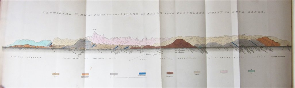
Take for example two important figures in 19th century geology, Roderick Impey Murchison and Adam Sedgwick. In 1827, they visited Arran, and then went on to examine the Old Red Sandstone in the far north. A record of their visit is found in the 1829 Transactions of the Geological Society. There are some fine fold-out sections and lithographs accompanying this report:
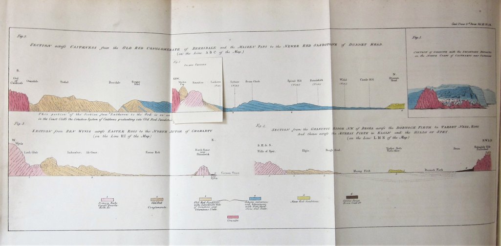
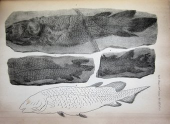
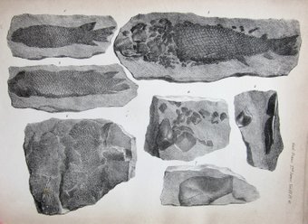
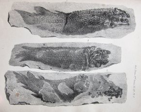
Lithographs of fossils found in the sandstone of Caithness.
In 1836, some nine years later, Charles Lessingham Smith found himself at a hotel on Arran. "The inn is very comfortable, considering always that it is in the Highlands. I have been waited on by a lassie without shoes or stockings, articles which seem very generally dispensed with throughout the island.....My landlord...elicited from me a very full account of myself. When I mentioned that I belonged to the University of Cambridge:
'Oh then,' says he, 'ye'll know Mr Sedgwick: awful bothers I've had wi' him. He was in Arran for three weeks, examining the island. But about a fortnight ago, here were two Germans, one of them practical engineer to the King of Prussia, indefatigable fellows. They found out two veins that neither Sedgwick, nor Murchison , nor Jameson, nor any of them had noticed. They didna care what they had to eat or drink a' the day, if they could but get a good supper; just gie them a bellyfu' before they went to bed, and it was a' they cared about.'
It is little vignettes like this that I want to illustrate in the remainder of this page, rather than the progress of the science itself as the 19th century proceeded. Such insights bring alive the participants, as above, where Sdegwick was obviously a difficult guest, or else give a picture of how the geology of the time was received within the public domain. This is of particular interest as the Highlands Controversy unfolded.
Incidentally, Lessingham Smith's Excursions Through the Highlands and Islands of Scotland in 1835 and 1836 is of particular interest. He is credited with a first ascent on Skye when he returned with a shepherd from Loch Coruisk, and he travelled right up to the far north coast. His image of Loch Eriboll from Heilem must be one of the first published of this region. William Daniell had depicted views of the north end of the loch, but nothing looking further to the south.
Amateur Geology
As the 19th century wore on, the interest in geology for the general public increased. As early as 1818, T. Walford's The Scientific Tourist through England, Wales and Scotland devoted over 17 pages to 'Geological Inquiries', including 11 pages detailing a large number of minerals. John MacCulloch was less enthusiastic about the amateur: "Every blockhead who has cracked a stone at Salisbury Crag must display a hammer. The world will never be the wiser for all their hammers." However, he was impressed by "the quarryman who accounted for me the fissure in a rock, by the earthquake which happened at the Crucifixion, [which] showed a bounding and philosophical spirit worthy of a seat among the geologists of the age."
Glaciation and the Ice Age were concepts not understood until the middle of the century, and the large 'erratic' stones carried by the ice over large distances puzzled some of the visitors. Dr Johnson noted that some of the local population thought "their earliest ancestors were giants, and these stones are said to have been thrown up and down by a giant and his mistress." John Knox thought these erratics were placed "to screen persons who were on the watch to kill the wild boar, the deer, the fox, the eagle, and other animals." Pococke, as we have seen, was particularly observant, noticing for example, on the top of "the mountain called Scarre in Lappick [Scurr na Lapaich, south of Loch Monar]... several sorts of shells, mostly of the welk kind, and not petrified; there is also a white stone said to be almost transparent, which I conjecture to be white flint."
William Daniell on his tour round Britain was clearly aquainted with the serious geological research of John MacCulloch. He quotes MacCulloch, for example, at Whiten Head on Loch Eriboll, where it "affords an opportunity of tracing the superposition of the gneiss to the quartz rock....the series of Loch Eriboll consists of limestone, succeeding to quartz rock and gneiss, and followed by the same substances in a regular order of appearance." What the Highlands Controversy was all about in a nutshell!
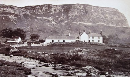
Inchnadamph, Looking to Stronechrubie. A photograph by G.W. Wilson.
A number of the contributors to the New Statistical Account of Scotland in the far north, all ministers of the church, also show a keen awareness of geology. At Assynt, the Reverend Charles Gordon was excited by the rock which "extends about a mile and a half, overhanging the public road. It is almost perpendicular" (possibly that at Knockan Crag), while at Stronechrubie, he spotted a "stupendous ridge of limestone rock interspersed with strata of sandstone." Nearby, the Reverend William Mackenzie stated that "All the track...to Layne [Assynt] being five English miles, abounds with limestone in different forms; but on the opposite side of the river Ah, there is not the smallest piece of limestone to be found....the severing of the high limestone rocks from the opposite bleak hills can hardly be accounted for but by ascribing them to some uncommon convulsion of nature." Perceptive indeed, for he was deep in the thrust territory that so perplexed 19th century professionals.
The Reverend James Campbell noted that "a rounded piece of native gold rather more than half an ounce, was found in the Burn of Kildonan...but although the discovery induced many other searches...no additional particle of the precious metal has been found." At Tongue, the Reverend Mackay Mackenzie was clearly aware of the important geological survey of Sutherland published in 1841 by Robert Hay Cunningham, and in addition he too was perplexed by the "Granite boulders [that] are frequent about Tongue village. Whence they have come is a problem not easy to solve."
Finally, at Tain, the Reverend Calder Mackintosh became positively ecstatic in his account of the area: "The traveller along the high road westward, as he issues from a territory that promises little to excite admiration, is suddenly astonished to find himself walled in upon his left, by a lofty precipice consisting of immense masses of stratified stone, piled one upon another in regular ascent, by the giant hand of nature - in one part cleft and scooped away in the form of a ravine, in another jutting directly out upon his path , and perhaps exciting a momentary shudder as looking up from beneath the spot, he beholds an enormous projecting mass seeming ready to tumble from its elevation of forty or fifty feet above his head, while at the same time, the rich clothing afforded by the ornamental trees...the ivy mantling...and there the birches.... confer an air of softnessthat renders it difficult to tell whether the prevailing character be the beautiful or the sublime." Mackintosh is capable of geological detail too: he states that the strata is composed "partly of gneiss, but chiefly of a kind of granite, of which no rocks are to be found nearer than the western coast of Ross-shire, and which often attain a very large size (one block, especially, known as the 'Big Stone of Morangie' containing at least 1400 or 1500 cubic feet), [and] seem to have been carried further after deposition but before the hardening of the clayey stratum."
It was at Tain where Catherine Siclair came upon an "enormous black whinstone about 50 feet round...Whatever our horse mistook it for, he suddenly sprung aside, threw his fore-feet over the opposite parapet and struggled violently to leap over it." She and her fellow passengers had to leap from the carriage. The stone turned out to be "a great geological curiosity, a special favoutite with scientific men." (from Scotland and the Scotch). Whether this was the 'Big Stone of Morangie' I cannot say.
In poetry, Keats provided a high point with his verse on Ailsa Rock:
Though answerest not for thou art dead asleep. Is but
Thy life two dead eternities
The last in Air, the former in the deep-
First with the Whales, last with the eglle skies-
Drowns't wast thou till an Earthquake made thee steep-
Another cannot wake thy giant size.
Keats also visited Staffa, which he called in his poem of that name "This Cathedral of the sea!"
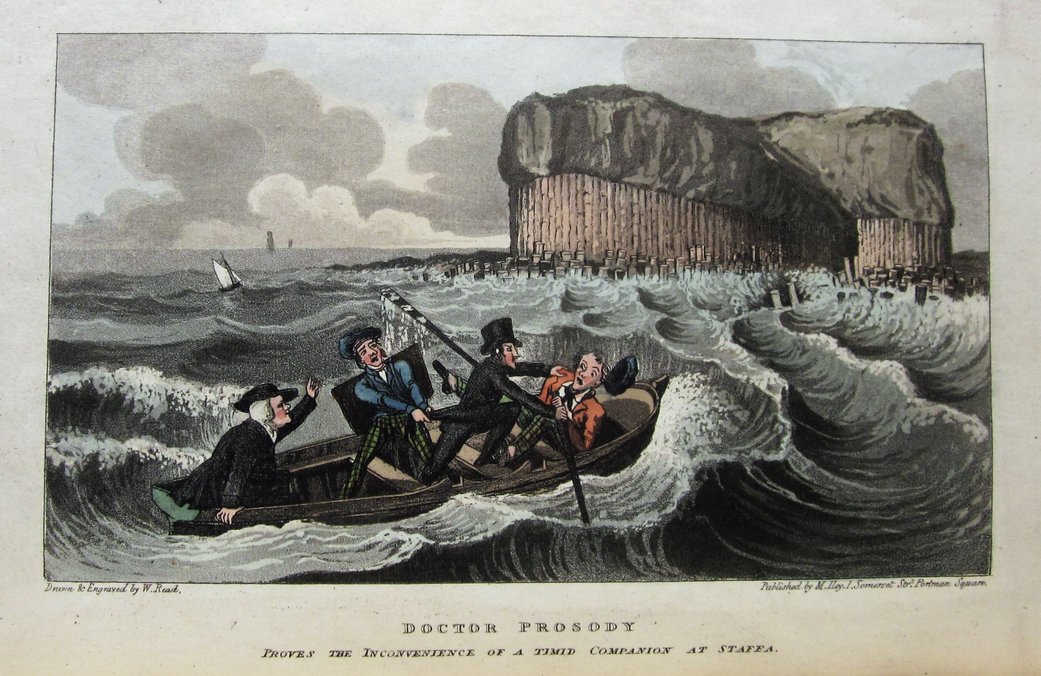
At the other end of the poetic spectrum, there is Doctor Prosody, travelling in search of the Antique and Picturesque in 1821, struggling with the science with his friend Factobend:
But various objects soon engage
The notice of each learned sage;
Not theirs the boorish apathy
Which thus could doze, while to the eye
A matter that could cause debate
Offered itself, though but a slate,
Or simple pebble, and they had
Laid down the antiquarian trade
To show their wond'rous information
On minerals, chrystallization,
Geology and all the arts,
Which shew our system's inward parts.
Nor could they one such matter settle
Without much trial of their mettle:
The mind of Prosody in vain,
Would try to love or entertain
Such arid studies, and instead
Of further troubling his head
With Factobend's continued chatter
(For neither knew much of the matter)
On Shetland, they sought out copper ores, and silver with cobalt mixed, which they had heard abounded there:
And for that purpose he had read
All that Geologists had said
And could discern the difference proper
Twixt clay and coal, and lead and copper.
The party landed and began,
Directed by our sage, to scan
Each rock and stone, and nook and cranny
Although no more than did my granny
Of mineralogy they knew
Yet to obey the sage they flew.
And of course they visited Staffa:
To Fingal's Cave their course they steer'd,
By ev'ry Highlander rever'd,
Where Prosody dimensions took,
And noted each in his place-book.
Amateurs, and the Highlands Controversy
My book, The Immeasurable Wilds, has a complete chapter on the Highlands Controversy, and I have written more on the subject on a page on this website, and this is not the place to describe further the events that led to the realisation that Sutherland contains some of the most remarkable geology in the world. However, I have come across one or two references which illustrate how the public reacted to the geological news as the research unfolded. I think it is of interest to see how the various paradigms were received within the public domain, adding a little more to the whole picture of this fascinating controversy.
The debate started in ernest in 1855, when Murchison visited Durness with Nicol to view the fossils that Charles Peach had found there. This led to Murchison's important paper read to the Geological Society in 1859, in which he proposed a model in which theregions where metamorphic strata lay on top of sedimentary layers formed an upward succession, laid down in the order in which they were now seen. He published a map with his paper in 1859, and shortly afterwards, another with Geikie setting out his vision in which much of the Highlands was covered with rock of the Silurian age. Nicol, of course, disagreed, but Geikie was to back up his mentor in his book published in 1865, titled The Scenery of Scotland, Viewed in Connection with its Physical Geology. This was aimed at the general reader, and Geikie used the opportunity to state clearly "It was not until 1855 that Sir Roderick Murchison....established the true relations of the rocks of Sutherland and Ross, and obtained the key with which he has revealed the structure of the Scottish Highlands - a discovery the importance of which it is hardly possible to over-estimate.
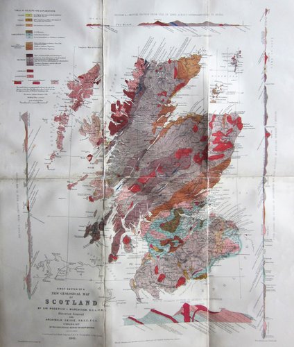
"First Sketch of a New Geological Map of Scotland." The map published by Murchison and Geikie in 1861, portraying many of the rocks in the north as Silurian in age.
In fact, Murchison's theories had already found favour with at least one member of the general public as early as 1860. In that year, Charles Richard Weld published a book Two Months in the Highlands, Orcadia and Skye. He travelled to the far north, where at Durness he visited Smoo Cave. He wrote:
"The geologist will look at the limestone at Smoo with greater interest when he knows that it contains curious fossils. The discovery was made in 1854 by Mr Charles Peach, a self-taught geologist...Originaly attached to the preventative service on the coast of Cornwall...Mr Peach availed himself of the opportunities afforded him when officially visiting wrecks on wild headlands to examine the rocks. In these he had detected fossils overlooked by previous observers, and has enabled older geologists to assign to hard and crystalline rocks, the age of which was unknown, a definite place in the Palaeozoic series.
"Mr Peach's discovery of organic remains in the Durness limestone was deemed so important by our great geologist, Sir Roderick Murchison, that he twice re-visited the north-west of Scotland, for the express purpose of again examining the geology of that district. On both occasions he was accompanied by eminent geologists; in 1858 by Professor Nicol, and in 1859 by Professor Ramsay.
"The result of these visits is not only extremely interesting, but also highly important, because it involves no less a change in the geological map of Scotland than referring to the lower Silurian epoch a vast region which has up to this day been considered to be of a primary age, and anterior to palaeozoic life.
"And as we are in the district made geologically famous by Mr Peach's researches, some account of Sir Roderick Murchison's labours and their results will not be out of place.
"Mr Peach's discovery of twenty-three well defined forms in the Durness limestone, comprising several genera belonging to the Lower Silurian rocks of Europe and North America, eleven being identical with American forms, led Sir Roderick to the conclusion that the red conglomerate and sandstone of the whole of the north-west part of Scotland is of very high antiquity; for not only does it underlie starta of the Lower Silurian age, but even the edges of the subjacent conglomerate and sandstone have been eroded before the Silurian deposits had been laid upon them.
"Sir Roderick also states that the most ancient stratified rock in Scotland, and, as far as he knows, in the British Isles, is the gneiss, which is exhibited in the north-western shores of Ross and Sutherland, where it forms the rugged basement of the whole stony super-structure. At Cape Wrath, and along the north-western caost, this gneiss has everywhere the same grey hornblende basis, traversed by many veins of bright-pink granite. It may be traced along the west shore of the Kyle of Durness; and near a little burn adjacent to the Ferry House the rock is charged with asbestos and actinolite.
"Sir Roderick's visit last year to the Highlands enabled him not only to confirm his previous views, but to strengthen them. In a communiucation that he made to the Geological Society in November last, he says that Prfessor Ramsay and himself 'not only saw no reason to depart from any of the views already published, but that they were enabled to strengthen them by laying down on a map a more correct outline of the formations than had hitherto been traced, by marking the principle faults, and by indicating clearly the transition upwards from the known Lower Silurian rocks into a superior micaceo-quartzose series (or the so-called 'younger gneiss'), which is entirely dissevered from the Old or Fundamental Gneiss. They further ascetained that, whenever eruptive rocks occurred, they did not interfere with or derange this ascending conformable Lower Silurian succession. Sir Roderick further expressed his opinion that the 'mica slates, clay slates and quartz rock of the southern Highlands will probably be found to fall into the same Lower Silurian category as the rocks of Sutherland.'
These researches by our eminent Director-General of the Geological Survey of Great Britain, entirely upset the long entertained belief that the great mountainous masses of red conglomerate and sandstone of the west coast of Scotland are detached portions of the old red sandstone, and Mr Peach's palaeontological discoveries have enabled Sir Roderick Murchison to define the great unfossiliferous conglomerate masses of Sutherland as of Cambrian age, the quartzites and limestone as Lower Silurian, and the overlying micaceous and gneissose schists and flagstones as also of Silurian age."
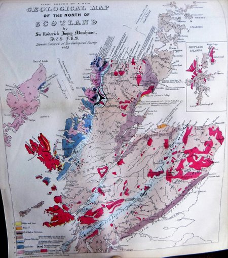
Murchison's First Sketch of A New Geological Map of the North of Scotland, which accompanied his paper given to the Geological Society in 1859. It is the first printed depiction of his paradigm in which the metamorphic rocks that lie over the sedimentary layers are of a Silurian age.
I have quoted the above passage from Weld's account in full because I think in a small way, it adds fascinating details to the complete picture of the Highlands Controversy. Weld was obviously well versed in the science, possibly a member of the Geological Society of London, and perhaps he had heard Murchison deliver his paper in 1859. That he decided to include such a technical description of Murchison's theories in what is a general account of a tour of the Highlands, aimed at a non-technical readership, is also of interest. He must have known of Nicol's opposition to Murchison's ideas, yet he makes no reference to them at all, nor to the problem of metamorphic rocks lying over sedimentary layers. It is as if for Weld (and indeed for much of the geological establishment), the "eminent Director-General of the Geological Survey" must be right by very virtue of his position. Certainly, here in print, we have an early example of the acceptance of Murchison's model, presented in a fashion that allows for no alternative views. The matter had been settled in 1859 for Charles Richard Weld.
Weld may well have attended the meeting of the British Association in Aberdeen in 1859, at which Murchison and Ramsay spoke following their investigations in the summer of that year. He gives a nice insight that extends beyond the science in a footnote on page 23:
"...a Society consisting of members of the British Association - many of great scientific eminence, calling themselves the Red Lions, are accustomed to dine together on one day during the week that the Association meet. At this reunion the professional buskin is laid aside, comic songs are sung, and hilarity is testifed by the philosophers growling in imitation of the animal from which the society takes its name, the growls being accompanied by a general wagging of coat tails. The effect of such preceedings, enacted by gentlemen who bear the character of being learned professors, on the astonished waiters at the hotel where the 'Red Lions' show off, may be imagined, certainly not described."
Whether Murchison or Ramsay were amongst the Red Lions wagging their coat tails Weld does not reveal, but later in the book (pages 315-16), he comes across them again on the Steamer heading south from Inverness on the Caledonian Canal:
"After my lonely wanderings in Sutherland, it was startling to find myself amidst a motley crowd of tourists. Where did they come from? But were they all tourists, I asked myself when, having obtained a seat on the quarter-deck, I was able to scan my fellow-passengers? Can those ladies in gorgeous silks, crinolined to an extent that makes me tremble when I see the inquisitive wind-puffs revealing ankles and legs, and loaded with nuggety bracelets, chains, and brooches - can these be tourists? Or those gentlemen near them with uncomfortable-looking coats, and boots that would fly to pieces before they had carried their wearer over half a dozen miles of rough road? Impossible; nor were they; for, as I afterwards ascertained, the majority were the fragmented remains of the British Association, who, in the form of male and female dilettanti, were digesting the severities of science amidst the beauties of nature, before returning to their southern homes."
So much for Charles Weld and his insights into science and scientists. There is no doubt that accounts like his, and books like Geikie's The Scenery of Scotland helped bed down Murchison's theories in both the public and the scientific domains. Text books such as Ramsay's Physical Geology and Geography of the British Isles went through several editions, all supporting the Murchison model without any reservations. The 5th edition of Ramsay's book was published in 1878, nearly 20 years after Murchison had first suggested the metamorphic rocks of the Highlands were of a Silurian age, and indeed after the controversy had been re-ignited in the south by Henry Hicks, yet it reads: "In the extreme north of Scotland....above the upper limestone we have a vast series of beds of mica-schist and gneissose rocks, mostly flaggy in the north-western region, but, in the eastern parts of Sutherland and Aberdeenshire, often so highly contorted and metamorphosed that they are, in some respects, similar to the more ancient Laurentian gneiss.
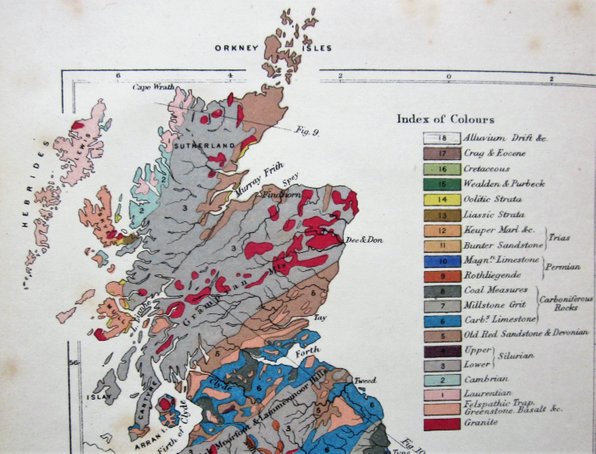
The map that accompanies A.C. Ramsay's "Physical Geology and Geography of Great Britain" which was published in 1878. It shows the vast majority of the Highlands to consist of Lower Silurian rocks.
Now these metamorphosed Silurian rocks....form by far the greater part of that rocky region known as the Highlands of Scotland...all the way from Loch Eriboll on the north shore, far south across the Grampains, to the Firth of Clyde on the west, and Stonehaven on the east."
It is worth noting, though, that there were voices expressing doubt, beyond that of James Nicol, for often he is depicted as a lone figure standing against the Murchison paradigm. For example, in the address given by the President to the Inverness Scientific Society and Field Club, William Jolly, HM Inspector of Schools and himself a geologist of note pointed out that the succession of the Highland rocks was "a peculiarly fascinating but most difficult piece of work for any geologist", and he added "I cannot say that the question has been finally settled." This was, of course, before Hicks had re-opened the subject in the south. Then, in 1882, he urged the members "to help towards the solution of this great question at their very door."
The Controversy Ends
The work of Callaway and Lapworth brought the Controversy to an end in 1883. Geikie, who had supported Murchison's model to the bitter end, was finally convinced of his error by his Geological Survey team, who then set about surveying in detail one of the most complicated regions of geology in the British Isles. A further 24 years passed before the official memoir of the north-west Highlands was published, a testament to the labour involved in sorting out the structure.
A more modest assessment of the geology of the area can be found in a most attractive little book, Cycle, Camp and Camera, which was published in 1903. It is written by two intrepid tourists, the first half by E.E. Henderson, and the second by J. Walker. Much of the text concerns their various adventures on their bikes in different parts of Scotland - I have written about it in the 'Camp and Camera' sub-page, which can be found adjoining the 'Intrepid Cyclists' section of this website. I thought I would end this long page on amateur geologists by looking at what J. Walker wrote about the geology of the far north, for whilst there is nothing remarkable in what he points out, he was obviously knowledgeable on the subject, and prepared to share his knowledge for his general readers in a less technical way than Charles Weld.
At Glen Roy, for example, he explains:
"No one who has seen high-water mark on a rocky sea-coast can doubt that these lines [the parallel roads] were old water beaches. The difficulty here was to know what held in the water then (as there is no barrier now) and especially at three different heights. The barrier is now satisfactorily explained as being, in the ice age, a thick mass of glacier ice which once filled Glen Spean and the lower part of Glen Roy, and which diminished through milder climate at three different stages until finally no shred was left behind.The geographical changes consequent upon the three different levels are not quite so simple as that, but as the phenomena are of great interest I will do my best to explain, as I have done my best to understand them. The ice sheet, then, sliding down from the Ben Nevis mountains (which are opposite Glen Roy, and downwards) blocked up the mouth of the Spean valley (in conjunction with the Great Glen ice) and also ascended up the lower part of Glen Roy. The Glen Trieg glacier, debouching also into Glen Spean further up, pushed across it and blocked up the Rough Burn valley there. The waters thus necessarily impounded in Upper Glen Roy had their overflow at its head (the col or pass being at the level of the highest line) into Loch Spey and thence down the Spey, forming at that time the highest beach or Parallel Road. With milder climate the Treig glacier now partly withdrew its block, and the Glen Roy waters falling to the level of the next Parallel Road now had their overflow by the col into the Rough Burn, passing eastwards through Loch Lagan again into the Spey. With still warmer conditions the Ben Nevis glacier next withdrew its block of lower Glen Roy, but still barred the mouth of Glen Spean. The impounded waters now fell to the level of the third beach or Parallel Road, and (as shown by the same horizontal line along Glen Spean) the waters now formed a long continuous crooked lake right down the whole of Glen Roy and up through Glen Spean and Loch Laggan, overflowing into the Spey over the col at Falls of Pattack. Finally, the Great Glen ice having melted away, and the Ben Nevis glaciers having shrunk into their own corries, the mouth of Glen Spean was now open and the Roy and Spean rivers began to flow westwards as they have done ever since. Possibly no races ever saw these changes, which may have taken thousands of years to accomplish, but the circumstantial evidence, particularly the identical levels of the cols or overflows into the Spey drainage basins with the heights of the various beaches, is so complete that geologists are fully satisfied: and now only these Parallel Roads (and the boulders) remain as evidence of a climatic condition vastly different from what is considered suitable for present day camping!"
Perhaps a map would help, but this is an admirably clear attempt to explain the rather complex drainage process at Glen Roy.
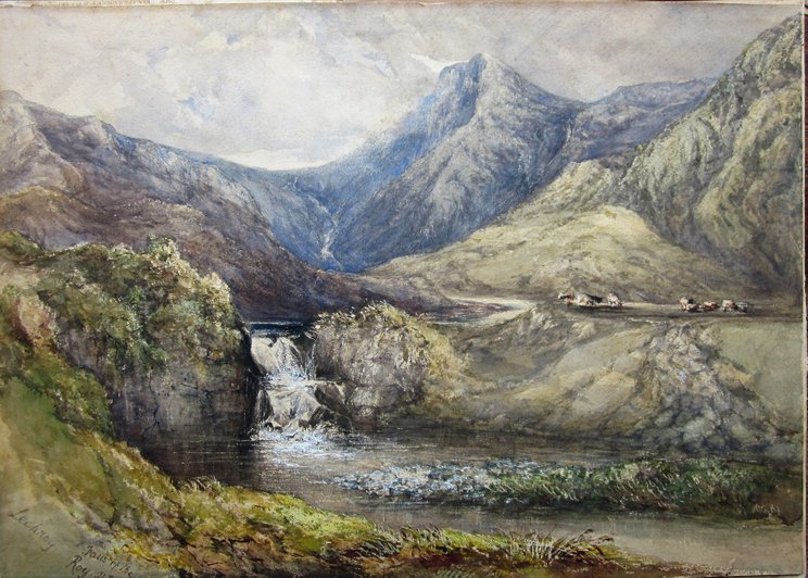
Glen Roy, a dramatic watercolour from my collection, artist unknown.
Walker's other observations are less detailed than those at Glen Roy. As he approached Durness, he notes that "We were fairly in the country of the Archoean gneiss, the oldest of British (or any other) rocks", and at Smoo Cave, observes that "the ancient limestone bed here is part of the same bed at Stronechrubie amd Knockan escarpments far to the south, but while they are cliffs, here it is below the levels of the streams, dropped down by a 'fault'." He camped at Loch Eriboll, where he "picked up specimens of the 'pipe rock'" (without any explanation of what that is) and then moved on towards Tongue:
"The moor is called the Moin ('moss'), and its name is now a celebrated one in geology, in connection with the adjoining Eriboll and Durness basins. Suffice it to say that the limestone in the latter yields fossils, which furnish clues to the supposed age of the whole Highlands. The succession is shown to be first (that is, lowest or oldest) Archoean gneiss, then Torridon sandstone, then Cambrian limestone, &c., above that, altered Silurian, then - Caithness way - Old Red Sandstone, &c. &c. Tremendous transformations have happened in this westward region , the rocks turned topsy-turvy, some mountains standing on their heads; and all due to the 'Moin thrust,' the final expression of a great force which broke through from underneath and pushed westward over-riding everything, and which now (exposed by denudation) runs as a distinct division line south for about a hundred miles. It is this geological history which has created the special features of the district, and which set geologists by the ears for something like thirty years. The full 'Memoir' on the subject is even yet not published."
I love the thought of all those geologists 'set by the ears', and think that, with the Memoir about to be published this is a good place at which to end this rather long page on amateur geological observations. I am impressed that you have come this far with me, but I would hope that there are few people who could see the landscape of the far north of Scotland without wondering at least a little bit about the processes that formed it.
Walker clearly knew his MacCulloch, for he quotes the famous passage from the second volume of his Highlands and Western Isles of Scotland, when he visited Assynt:
"Round about there are four mountains which seem as if they had tumbled down from the clouds; having nothing to do with the country or each other, either in shape, material, position, or character, and which look very much as if they were wondering how they got there."
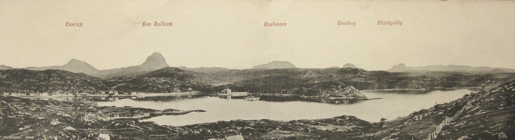
The mountains of Assynt, wondering how they got there. An early panoramic postcard with Lochinver in the foreground.
"Mr Peyton...skipped about with his hammer, peering here and there, whacking this, tearing at that, never still."
Description of an amateur geologist by the Rev. A.E. Robertson, from "The First Munroist" by Drummond & Mitchell.