Murdoch Mackenzie's 'Orcades': 18th century mapping of the highest quality.

Title cartouche of the first map in Mackenzie's 'Orcades', 1750.
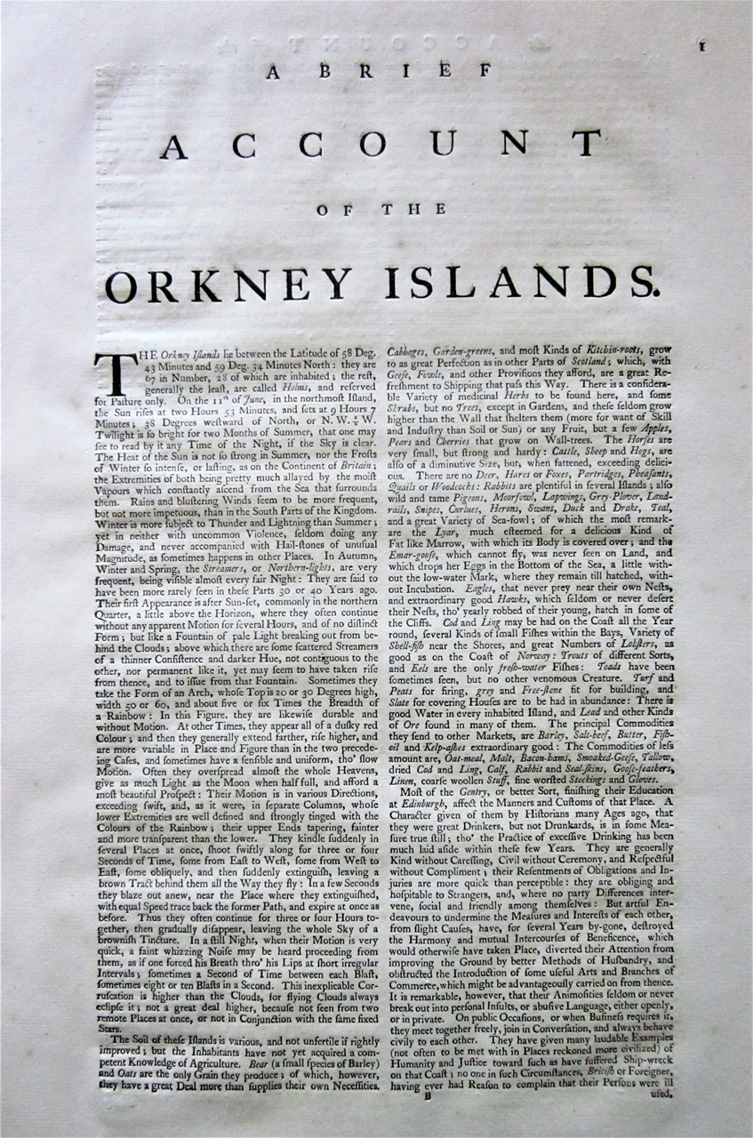
In 1750, Murdoch Mackenzie published one of the most important pieces of cartography of the 18th century. Called 'Orcades', it comprised a detailed description text of the Orkney Islands, together with eight highly detailed maps. Those of the Orkney region had been surveyed using the triangulation method, the first time it had been employed on coastal charts. These surveys led to maps of impressive accuracy. It was much needed, as the seas depicted, notably those of the Pentland Firth, are among the most dangerous in the British Isles, with tides that run as fast as any in the World. It is after all where the Atlantic Ocean meets the North Sea.

Dedication on the first of the 'Orcades' maps.
In order to pay for this survey, Mackenzie collected together an impressive list of subscribers, including the Earl of Morton, who seems to have ordered 30 copies in advance. In fact Morton, a keen supporter of scientific ventures, must have been crucial to the whole project. Some ten years earlier, he had, through the auspices of The Philosophical Society of Edinburgh, despatched Alexander Bryce to survey the north coast of Scotland which resulted in his Map of the North Coast of Britain.... in 1744. Both Bryce and Mackenzie had been pupils of Colin Maclaurin, a mathematician in the Chair at Edinburgh University, and another important figure in these surveys. It seems likely that Murdoch accompanied Bryce, and assisted in the triangulation measurements, assistance that would have stood him in good stead when it came to his own survey of the Orkney Islands.
The maps follow 13 large pages (in double columns) of text which include, as well as An Account of the Orkney Islands, detailed sections on the various tides, rocks, etc. found in the various regions. The maps are very large. To see them in satisfactory detail I suggest you investigate them on the National Library of Scotland website where they are displayed in a fashion a good deal more helpful than anything I could offer on this website. However, I will draw your attention to a few details.
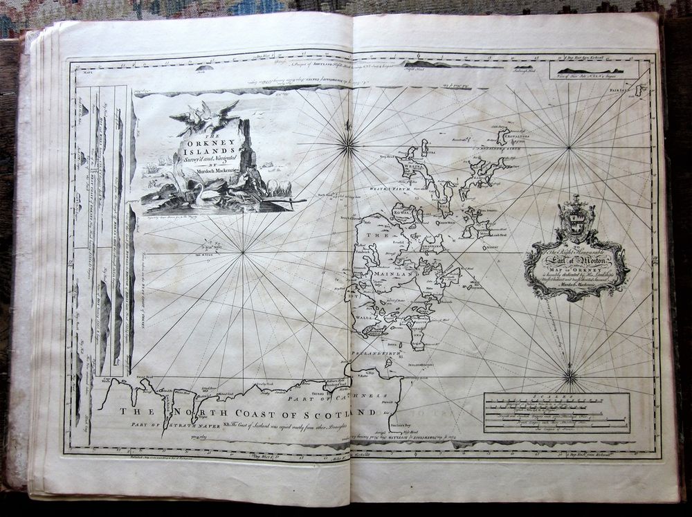
"The Orkney Islands, Survey'd and Navigated by Murdoch Mackenzie." The first map in 'Orcades'.

The key to the second map shows the sort of detail the charts provide for the sailor.

Detail of the area to the north of the Pentland Skerries, showing the help the charts provide for the mariner picking his way through the Pentland Firth.

Stroma and Swona are islands that lie within the Pentland Firth. This detail shows the recommended path that ships should follow, avoiding the whirlpools and eddies that swirl around the islands.

The entrance to Hoy Sound, with Stromness at the top. The hills marked were obviously an aid to navigation, and other details on the land, such as 'Lead Ore here' are of interest. The map is said not to show the Old Man of Hoy, but I wonder what the cylinder symbol seen at Stour is meant to signify.
The last three maps in Orcades do not, in fact, continue the description of the Orkney Islands, but rather, they show in some detail the island of Lewis, which lies off the west coast of Scotland. Lewis had never been depicted accurately up to this time, often shown with a flat instead of a pointed north end.

Detail of a map published by Emanuel Bowen c.1747. He has incorporated Bryce's findings from his map of 1744, but Lewis is still depicted with a flat top.
Mackenzie's map at last gives an accurate depiction of the shape of the whole island.
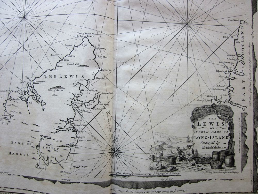
"The Lewis, or North Part of Long-Island Surveyed by Murdoch Mackenzie." A detail from the first of three maps by Mackenzie found in the Orcades set.
However, not all the details on this map were entirely accurate. The rock called Skerinoe, for example, was said to be out of position by 4 miles. Such inaccuracies on a land map at this time were not uncommon, and could be annoying, but not fatal. On a sea chart, it could lead all to easily to disaster and shipwreck. Mackenzie, by his own admission had not surveyed the Western Isles as methodically as he had those of Orkney, and this led to an unfortunate controversy in Mackenzie's old age which I shall describe on another page.
, showing the rock Skerinoe in the wrong position.")
Detail from Mackenzie's map of the North Part of Long-Island (Lewis), showing the rock Skerinoe in the wrong position.