5. Oct, 2021
The Immeasurable Wilds. What my book is about (Part Two).
Culloden was a key moment in the history of the Highlands. It brought the area to the attention of the whole Nation, which up to then had hardly thought about the far north of Britain. The interest of intrepid travellers was aroused, and visitors began to make their way to those remote regions from the 1760s onwards. Thomas Pennant made two trips to Scotland, the first in 1769 and the second in 1772. He was an inspiration for Dr Johnson, who famously reached as far north as Inverness with James Boswell in 1773. An even earlier adventurer was Dr Richard Pococke, who in 1760 managed to get to Cape Wrath itself, and in 1776 the Reverend Charles Cordiner described in detail his journey over Ben Hope to reach the broch, Dun Dornadilla, that still lies next to Loch Hope. The achievement of all these travellers was great, for the only road into Sutherland in the 18th century was up the east coast as far as Thurso. They have all left fascinating accounts of their travels.
The Highlands Improved
As news of these northerly regions began to spread, it became clear that the Highlands needed improvements at government level. Men like James Anderson and John Knox were sent to Scotland by those keen to find out what was needed, and in 1801 Thomas Telford devised a huge scheme that included the construction of a number of roads into the far north, improvements to harbours, and the construction of the Caledonian Canal, all of which took over twenty years to complete. My sources for the description of this project include the reminiscences of Joseph Mitchell (whose father was one of the key members of Telford's team) and the poet laureate Robert Southey who in 1819 spent some time watching Telford at work.
Once the roads were completed, the tourists began to flood in, though it is true to say that few made it to the very far North-West. My text includes accounts from James Hogg, who reached Loch Maree in 1803, while in the same year the Reverend James Hall approached the area from the east. William Daniell, who made a tour of the entire coast of Britain between 1814 - 1825, did much of his travel by boat, but left detailed descriptions of what he found when he came ashore, and more importantly still, a superb collection of aquatints, many of which in Scotland depicted areas that had never been seen in print before. Other visitors I mention included those from the world of the arts like Keats and Mendelssohn, and of course, Royalty, led by Queen Victoria and Prince Albert. Their enthusiasm for the country led to their purchase of Balmoral in 1852.
The Scientists
I devote the last two chapters of the book to the scientists, who were lured north, sensing that this was virgin country that had barely been touched by progress. James Robertson was despatched from Edinburgh to study the flora of the area, and once news of the wonders at Staffa had been released by Sir Joseph Banks, geologists from Europe as well as Britain hastened north to see what they could find. These included Faujas St Fond from France, Necker de Saussure from Switzerland and Ami Boue (also French) who published the first geological map of Scotland. But pride of place must go to John MacCulloch, who not only carried out important survey work throughout the entire country (his findings remained a standard reference for anyone exploring the geology of Scotland throughout the 19th century), but also wrote an entertaining if controversial account of his travels in 1824.
The last chapter is devoted to what is called The Highlands Controversy, a fierce debate relating to the age and succession of the rocks in the far North-West. The establishment, in the shape of the forceful Sir Roderick Impey Murchison, saw the succession as a simple process, the rocks deposited as seen in the order one finds them now. A maverick Professor at Aberdeen University, James Nicol, was brave enough to argue otherwise, believing something much more complicated to have taken place. A period of 20 years was needed before he was eventually proved to be correct. Huge lateral forces had shifted vast quantities of ancient rock over much later deposits, and Sutherland and Ross-shire are now famous sites for what is called thrust faulting, attracting geologists from all over the world.
My book therefore covers a period in which the region of north-west Scotland went from a state of ignorance so far as the south is concerned, to one of world recognition, at least in the field of geology. Since the introduction of the NC500 road route, many more people are discovering the astonishing scenery that can be found there, and I hope my book will bring alive the history of an area that until recently has received little attention.
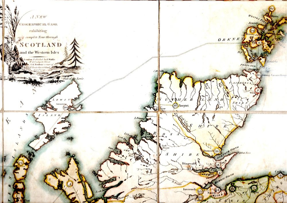
The image at the top of this post is a detail from J. Wallis's New Geographical Game published in 1792. Children were invited to visit 100 sites in Scotland, but only one was in the far north-west: No. 16 "Assynt, in Sutherlandshire, [which] exhibits an assemblage of shattered mountains, as it were heaped on each other, and seemingly involved in a tremendous manner." Modern geology has proved this to be completely correct.
Details of my book, The Immeasurable Wilds can be found at:
https://www.whittlespublishing.com/The_Immeasurable_Wilds